TL;DR: Gutenberg's revolution, when it finally arrived on North America in the holds of ships, printed its religious scriptures on vellum and rag paper and bound them in leather. Literally, it was dead skin all the way down. It published the same title over and over, a sacred book that tells you what a soul is and where it goes.
Well, guess what? The Adena culture did that exact same thing in Ohio since before Rome was a fucking empire**. It was the same technology (soft stone plates using red and black pigments), using the same specialization (printers), with the same purpose (theological content), with just one production decision difference: Europe printed their theology on the skin of dead calves and wood. The Adena printed it on** your skin, while you were alive, at the thirteen places where your souls were.
What is writing?
Yes, I know, some of you wanted the simple TL;DR so you can run to the comments and dunk on indigenous peoples in North America inventing writing. Sorry mate, if that’s you, you’ve got to answer me first that question: what is writing?
“Prehistoric Ohio had no writing, so calling anything a "printing plate" is a category error, checkmate you communist, delete your post.”
Hey. Bitch. Define writing. Because it turns out, every word you reach for is about to betray you.
If you don't give a fuck, skip to Part II where we get to the actual history lesson.
Part I: The Part Where Etymologists, Linguists, and 18th Century Colonists Explain Why Your Definition of Writing Sucks
Start with "write" itself. It comes from Old English writan, and writan does not mean recording language. It means "to score, outline, draw the figure of." Its Proto-Germanic parent means to "tear, scratch." The philologist Carl Darling Buck surveyed the vocabulary and found that words for "write" in most Indo-European languages originally mean "carve, scratch, cut" (Online Etymology Dictionary).
In Latin, it's scribere, the root of scribe and scripture, is another scratch word. Okay how about Greek: graphein, the root of every -graphy you have ever paid tuition for, means to scratch, to carve, to incise. When the Greeks saw Egyptian temple carvings and needed a name for them, they built it from hieros, sacred, and glyphein, to carve (Online Etymology Dictionary). A hieroglyph is, in the plainest possible translation, a sacred carving. That's going to be very funny in about eight hundred words.
Let’s keep going though. "Text" comes from Latin texere, to weave; a text is etymologically a woven thing, a cloth (Online Etymology Dictionary). "Book" is Old English boc, from the same root as "beech," most likely from beechwood tablets with runes cut into them (Online Etymology Dictionary).
"Library" runs back to Latin liber, which named a book because it first named the inner bark of trees (Online Etymology Dictionary). And "read" is the strangest of all: Old English raedan meant to advise, to deliberate, to interpret, and it survives in "riddle." Most European languages built their reading word on "gather up," like Latin legere. English is nearly alone in deciding that reading is riddle-solving (Online Etymology Dictionary).
So the entire vocabulary of literacy, the whole goddamn marble edifice of Western Letters**, is a pile of Neolithic craft words: scratch, carve, cut, weave, bark, beech, riddle. There is nothing in the etymology about alphabets**. There is nothing about what you’re recording. It definitely doesn’t have to be speech (see: whatever screeching noises are coming out of the West Wing this week). The alphabet is a late tenant in a very old building known as writing. The building was always a workshop where people cut marks into surfaces while other people interpreted them.
Oh, and this isn’t me being fucking cute. Of course, academics argue their livelihoods over this shit. Elizabeth Hill Boone, working on Mexican and Andean systems that record staggering amounts of information without recording speech, defines writing as "the communication of relatively specific ideas in a conventional manner by means of permanent, visible marks" (Boone and Mignolo 1994, 15). Under that definition, Aztec pictorial tribute rolls are writing, Mixtec dynastic histories are writing, and the knotted cords of the Inca, which ran the accounting of an empire, are writing that dispenses with the page altogether. Linguists in the other camp insist that only marks tied to speech count as "full" writing. Geoffrey Sampson gave the two kinds names, glottographic for speech-recording systems and semasiographic for idea-recording systems, and John DeFrancis spent a career insisting that the semasiographic kind is not writing at all. It is a genuine debate and reasonable people are on both sides of it.
But notice what the debate is about. Nobody disputes that semasiographic systems store and transmit specific, conventional, recoverable information across generations. The fight is only over whether that achievement gets to borrow the prestige word "writing." It is the most trite, silly, stupid fucking etymological arguments about etymology out there, because no one worth their academic salt is debating whether indigenous peoples were encoding information through scratching, weaving, and riddling already. Which as we defined, is the base definitions of the etymology to begin with.
Yep, academics can be just as fucking pedantic as Reddit commenters, only they get prestige for it while you get negative karma. But I digress.
This isn't a new debate either. Historical eyewitnesses, European fucking eyewitnesses, reach for “writing” to describe indigenous encounters again and again. When the trader James Adair described Chickasaw tattooing in 1775, done with the toothed jaw of a garfish and pigment made from pine soot, he reported that the marks were "as legible as our alphabetic characters are to us" (Reilly 2013, 179). Legible. His word, and he was a man who kept goddamn ledgers. The man knows ledging.
The botanist William Bartram, visiting the Creek towns in 1791, said the designs "seem like merzitinto [mezzotint, an early printing form] or a very ingenious impression from the best executed engravings," dividing the body "into many Fields or Tablets, which are ornamented or filled up with innumerable figures," and he concluded they were "hieroglyphics, or mystical writings, or records of their tribe, family & memorable events" (Reilly 2013, 180). Wampum belts archived treaties that colonial governments were held to decades later. On the Plains, the winter counts kept chronicles, one pictograph per year, and the Lakota writer Mary Crow Dog described them as "picture writings on buffalo skin, which told our people's story from year to year" (Calloway 2003, 1).
The historian Andrew Newman points out that when Delaware people and colonists argued about the past, they were really arguing "about the media of history and memory," about whether a spoken chain of custody, a belt of shell beads, or a piece of alphabetic paper was the reliable container for truth (Newman 2012, 2-3). Every party to that argument understood the others were keeping records. They just fought about whose records counted.
So, if you are still following, guess what? I don’t give a fuck about where you fall on that line, because Newman's point stands today. Where you fall will likely tell me about what you're trying to argue about history and memory today.
And none of that will change that if you think indigenous peoples didn’t encode information because they weren’t using an alphabet, you’re the fucking dumbass not jiving with the 21st century literature. Or the 18***\**th* century colonial settlers.
Anyways. Adena. 13 Souls. Tattoo artists.
Part II: The Part Where Thirteen Little Rocks Become a Print Shop
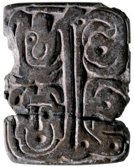
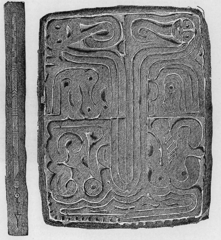
In December of 1841, a crew of laborers in Cincinnati was hauling away a twenty-five-foot burial mound that stood at the corner of Mound Street near Fifth, because it was in the way of the street grade, and the street grade was the most sacred thing anyone downtown could think of (Penney 1980, 8. Penny records it as “Main and Third,” but actually that was an earlier, destroyed mound already flattened for the street grade. American Pioneer 1843, 195. Welcome to Ohio, where we either bulldoze our mounds or build golf courses on them). Near the center, below the level of the surrounding ground, they hit a decayed skeleton. It was the body the whole mound had been raised over. With it lay two pointed bone implements, each about six inches long, or seven, depending on which of the two white men later claiming to be the tablet's rightful discoverer you asked (Penney 1980, 8-9). With the bones and the two sharpened points lay a small tablet of fine sandstone, about five inches long, carved on one face with a design nobody could read, worn with grooves on the other, and marked with "spots over it, both back and front, as if it had been sprinkled with blood" (Penney 1980, 18-19).
Two years later, a Cincinnati periodical called American Pioneer published the first description of the thing: "Could we suppose those who made it to be possessed of the art of stamping or printing, we might imagine this stone to be an engraving for that purpose. Its face is almost as even as the engraving from which we print" (Penney 1980, 17).
There’s some serious fucking irony in a print shop full of 1840s newspapermen looking at a two-thousand-year-old carved stone, recognizing their own printing equipment, and then talking themselves out of it in the same sentence. Because could we suppose those who made it possessed such an art? Obviously not. The people who made it were Indians, and everyone in 1843 knew Indians did not have printing, because printing requires writing, and Indians did not have writing. Duh. So the tablet got filed under "hieroglyphical stone," which is to say under "mysterious sacred carving," (please laugh now) and the mystery got handed down the century to the Lost Tribes people and the Mound Builder race people and the ancient aliens peoples and eventually the Nephilim dudes, who are still trying to get me to hand out their literature like the worst door-to-door salesman.
Well guess fucking what? The newspapermen were right the first time. It is a printing plate. We can prove it is a printing plate. We know what the ink was made of, because it is still caked in the grooves. We know the press run was small and the edition limited. We know the publisher, roughly, and the distribution network, and we have a solid working theory of the content, which is more than I can say for most things published in Cincinnati.
But the printing surface was not paper. The evidence says it was leather, and skin, including the living kind, attached to people. The Adena were printing on human beings, and the thing they were printing was, as best we can reconstruct it, a diagram of what a human being is. It was a map of the body's souls. Plural, because you have more than one, and the Adena marked every place where one of them was parked.
Here is the definition I am going to use of writing (yes, I’m not a copout of my own question): a writing system is a set of standardized, conventional, reproducible marks that carry specific meaning to people trained to read them. And a device engineered to mass-reproduce such marks in pigment on a surface has a name too. It is called a printing plate. And prehistoric Ohio has at least thirteen of them.
The engraved Adena tablets are a tiny sacred indigenous canon with thirteen core examples by the classic count, seventeen or eighteen if you take every reported and since-lost specimen, all of them from the Adena world of southern Ohio, northern Kentucky, and western West Virginia (Penney 1980, 3; Caldwell 2015, 105). They are absurdly small. The literature calls them "postcard-sized inscribed slabs." The Cincinnati Tablet is twelve and a half centimeters long, and it is one of the big ones (Caldwell 2015, 105; Penney 1980, 36). Your cell phone is probably bigger than one of these. Nearly all are cut from soft, fine-grained sandstone, mostly Berea; one, the Gaitskill Clay Tablet, is (shockingly) unbaked clay (Caldwell 2015, 105; Dragoo 1963, 97; Penney 1980, 10-11). They are hand-sized rectangles, roughly two to three in their proportions, flat-faced, carved on one side or occasionally both, with no perforations and no way to hang them as ornaments (Penney 1980, 10-11, 17). Whatever these were for, they were for holding in the hand and doing something with, face down.
Of the entire canon, exactly one engraved tablet, the Wright Tablet, came out of a professional excavation, and it was a broken fragment in redeposited village trash (Penney 1980, 4). Every other tablet was dug by farmers, curiosity-seekers, and gentleman antiquarians between 1832 and 1950. The Waverly Tablet was pried out of a mound by two guys who were "cutting away at the mound" and sold to a passing doctor while the dirt was still on it (Penney 1980, 9). Skinner’s 1886 record says Dr. Hurst “obtained” the tablet from the diggers mid-excavation, a.k.a. money was exchanged for said tablet while they were still digging. The Lakin tablets turned up in 1950 while a Mason County farmer was "destroying a mound on the home property," a phrase archaeologists read the way most people would read "while burning down the Alexandria library" (Penney 1980, 9). The Wilmington Tablet came from an 1881 dig where the excavators found skeletons arranged like wheel spokes, heads to center, above a vault holding a face-down skeleton that they said held the tablet "clasped" in the bones of its left hand (Penney 1980, 5-6). No other Adena artifact has ever been found clasped in anyone's hand, so that detail is probably embroidery. We can be confident these particular excavators embroidered, because a month later a second "tablet" surfaced in their same mound, engraved with a man in trousers and shirtsleeves, a woman in a dress, a striped tiger, and a crocodile (Penney 1980, 6-7). Pranksters had salted the site, and the excavators fell for it. Their published report praised the trousered man's "bold and massive" features as just what "a student of ethnology would expect" of the Mound Builders (Penney 1980, 6-7). Dragoo’s Cresap dig also produced an engraved tablet under professional supervision, a turtle carved in the round, three grooves worn into its flat belly, red ochre packed into the grooves, broken in antiquity and kept in use long after it broke (Dragoo 1963, 89; Caldwell 2015, 105). It is the only effigy tablet known from the entire tradition.
This sort of fake vs. real shit has plagued Adena tablets, and much of moundbuilding archaeology, since its inception. Grave Creek is another example, because that one mound produced both a real tablet and the most famous fake "writing" in American archaeology, and the nineteenth century chose wrong. The real artifact, the Grave Creek Tablet, was a sandstone slab with concentric-circle designs; it is now lost, and we know it mainly through a sketch Henry Schoolcraft made in 1844 and a "corrected" engraving drawn by Captain Seth Eastman, a West Point drawing instructor who idealized the design and, as far as anyone can determine, never went to Moundsville (Penney 1980, 6-7). The celebrity fake, though, was the so-called Grave Creek Stone, a little disc covered in what looked like alphabetic characters, which surfaced conveniently around the time the mound's owner opened it for paid admission. Learned men in two hemispheres declared it Phoenician, Celtiberian, runic, or, you know, whatever their dissertation needed it to be. But Squier and Davis, surveying Ohio's monuments for the Smithsonian in 1848, said of it, "Until it is better authenticated, it should be entirely excluded from a place among the antiquities of our country" (Squier and Davis 1848, 274). On the previous page they had already disposed of a set of mica sheets from near Lower Sandusky that had been announced as tablets inscribed with "the history of some former race": the "characters" were natural markings, on a variety of mica that mineralogists, without irony, call hieroglyphic mica (Squier and Davis 1848, 274).
Again, I find some serious fucking irony in the fact that America spent the nineteenth century frantically hunting the mounds for writing, meaning “alphabets,” looking for a lost white race. They authenticated frauds, imagined characters in sheets of mica, and shipped the fantasies to Europe. And the entire time, the actual information technology of the Adena world kept surfacing at its feet: standardized, conventionalized, reproducible engraved plates, sacred carvings in the most literal sense available, which got shrugged off precisely because they did not look like an alphabet. They were looking for hieroglyphs so hard they threw out the actual fucking hieroglyphs.
But Penney, who did the first full art-historical autopsy in 1980, showed that the thirteen designs resolve into four matched pairs plus close cousins: the Lakin A matches the Gaitskill Clay tablet, the Wilmington matches the Meigs County tablet, the Wright matches the Berlin tablet, and the Allen matches the Grave Creek tablet (Penney 1980, 12; the matches were first spotted by Webb and Baby 1957, 83-92). The same motifs, the same compartmented layouts, and the same figures recur from mound to mound across three distinct regional style zones: a southwestern Ohio group, a Kentucky group, and an upper Ohio River group, each with its own local carving manner (Penney 1980, 24-26). Sean Rafferty's line about Adena mortuary ritual is that these regional "dialects" are of one shared "grammar" (Caldwell 2015, 107). Thirteen unrelated doodles, these are not.
Stratigraphy at the Cresap Mound in West Virginia found that crude grooved tablets run through the early and middle Adena layers, and the fine engraved style appears only at the top, in the late Adena horizon, roughly the last two centuries BC and the first two AD, when the Hopewell fluorescence was already warming up next door (Dragoo 1963, 101-102; Caldwell 2015, 105-107). The tablets are the late, standardized, perfected output of a long tradition. Which is what you would expect, because that is how publishing works: you don't get movable type printing until somebody has been scratching on things for a very long time.
So how do you prove a rock is a printing plate? You do forensics on it, the way you would on any tool. You look for design features that only make sense in use, look for residues, look for wear, and then build the thing and test it out.
Start with something you probably would never notice unless you thought like an HP Inkjet. The Wilmington and Meigs County tablets are usually described as bilaterally symmetrical, a bird design mirrored down the middle. They are not. On each of them, the carver systematically reversed figure and ground across the midline, meaning on the left side the bird's head stands up in relief with the background cut away, and on the right side the same head is cut into a raised background, positive on one side, negative on the other, down to the scallops of the tail (Penney 1980, 17). It only resolves into a design in one circumstance: the contrivance is "obvious and... seen to best advantage in the graphic image the tablet would print" (Penney 1980, 17). In other words, the carver was composing the impression, and was fluent enough in the difference between plate and print to play positive against negative for effect, which is a printmaker's trick, and a fairly show-offy one.
If you continue examining the tablets, you’ll find six of the carved tablets carry a raised border with a trough running just inside it, a curb to control liquid pigment sloshing off the design field; the linear-incised tablets, which would print by a different method, don't have it and don't need it (Penney 1980, 18). The Gaitskill tablets came up stained with red pigment accumulated in the carved-away recesses, which is exactly where intaglio ink) sits (Penney 1980, 17-18). The Meigs County Tablet has brown pigment caked along the top edges of its incised lines while the interiors of the lines are clean and fresher than the surrounding stone, which is what a plate looks like when it has been inked and wiped clean, repeatedly, by somebody maintaining their equipment (Penney 1980, 18). And the Cincinnati Tablet, remember, came out of the mound sprinkled with something that looked to its finders like blood, front and back (Penney 1980, 19).
Then there are the backs. Five of the engraved tablets carry worn grooves on their reverse faces (Penney 1980, 21). For decades the grooves fed two rival theories. Camp one: they are whetstone wear from sharpening pointed bone tools, because the tablets keep company with bone awls in the ground. For example, William Mills opened the original Adena Mound in 1901 and found a grooved tablet lying in the central tomb with a set of eleven elk and twelve deer bone awls (Mills 1902, 470-471; Deter-Wolf 2013, 53). The Cincinnati Tablet itself came with its two long bone points; the 1843 writers thought the grooves looked "worn by whetting pointed tools" (Penney 1980, 22). Camp two: they are mortar wear from grinding pigment, because at the Natrium Mound, Ralph Solecki found a faceted lump of hematite, the mineral you grind for red ochre, lying directly in a tablet's groove, almost like a crayon left in a sharpener (Penney 1980, 22; Dragoo 1963, 99, 105). Dragoo's Cresap excavation then buried the question in even more tablets, with twenty-two tablets from one mound, red ochre stains on nearly all of them, a thick pasty red deposit actually burned and fused into one groove, faceted hematite chunks scattered through the same features, and the facets on the hematite fitting the grooves on the tablets (Dragoo 1963, 88, 92, 99, 105). Little limonite cup-stones lay nearby with polished rims and ochre stains.
These cup-stones were paint pots (Dragoo 1963, 105-106).
Yes, both camps were right. Every tattoo artist picked up what the fuck I was describing probably halfway through the last paragraph. A flat engraved plate that prints a standardized design in red pigment, whose back sharpens bone needles, found in the ground beside the needles and the pigment and the paint cups.
That is a goddamn tattoo kit.
Webb and Baby said so in 1957, proposing that the shaman would "draw or stamp upon the body of the individual the appropriate symbols of the cult," in red ochre mixed with grease, "or he might use some of the blood of the devotee," ground on the same stone that had sharpened the awl used in the bloodletting (Dragoo 1963, 99). Martha Otto, publishing the Low Tablet in 1975, believed the grooves on the Adena tablets are from sharpening bone needles used for tattooing, and the ochre in the grooves is tattoo pigment manufacture (Deter-Wolf 2013, 53). Duncan Caldwell's summary of the current position is that the tablets served "both for printing templates on skin and for sharpening the awls that made them permanent during ceremonies that combined tattooing and bloodletting" (Caldwell 2015, 108).
So, the tablets were a stamp, a stencil, and a sharpener in one hand-sized tool. You print the pattern on first, then you needle it into the skin. Bartram's Creek tattoos we discussed above that looked like "a very ingenious impression from the best executed engravings" stop being a figure of speech and start being a description of process. Movable type is starting to sound less bitching, now, innit?
Now, in fairness, there’s still debate over exactly what was being tattooed. Penney thought his own intaglio method ruled living skin out, since the rub-from-the-back technique wants a medium you can press down into the grooves, so he nominated soaked leather (Penney 1980, 19). Webb and Baby wanted skin and clothing both (Webb and Baby 1957, 96-97). Otto wanted the needles and the pigment (Deter-Wolf 2013, 53). Caldwell’s synthesis what Iquoted above: that templates were printed on, then needled permanently.
And yes, somebody actually tested the printing press to prove it was a printing press. In the late 1970s David Penney took two plaster casts of the Cincinnati Tablet at the American Museum of Natural History, dusted the design face with talcum powder, scraped the excess off the flat tops with a piece of cardboard, and lifted the design with a static-charged cotton cloth. The powder came away reproducing the engraving "with fine and complete articulation of detail" (Penney 1980, 20). He also worked out the deluxe edition: rub the whole face with graphite, press soaked leather onto it, and the Berlin Tablet prints its design reversed-out inside a solid dark field, a cartouche effect you cannot get with liquid ink (Penney 1980, 19-20). Graphite is not a guess of what they could have used, by the way; lumps of it came out of the ground with both the Berlin and Lakin tablets (Penney 1980, 19).
Penney even guessed at what the product line looked like. A single tablet image stamped on a garment, he wrote, “would look as incongruous as a rather oversized laundry mark” so he pictured the images repeated into allover patterns on leather, “looking something like early Turkish carpets” (Penney 1980, 21).
And finally, in case someone thinks this was the work of one great genius (or alien. It’s always aliens), at Cresap, the finest tablets were not the property of some buried big man. They were found in a burned area at the summit, thrown into a great fire at the end of the rites, with none of them attached to any individual burial. Dragoo interpreted them as the sacred equipment of the cult group itself, kept by a specialist but owned by the institution, and formally decommissioned when their work was done (Dragoo 1963, 100). The Florence Mound produced the same example of unengraved tablets in a big fire pit at the mound base with no burials attached (Dragoo 1963, 100).
When the print run ended, they didn't sell the press so much as have it go out in a literal blaze of glory.
Part III: The Part Where You, Personally, Are Actually a Committee
Okay, so let’s say you’re still with me. If the tablet is a plate, and it is writing in the sense of conveying information, then what the fuck is it saying?
Well, I hope you have your glasses on, because you’ll need some literal depth of field for this one.
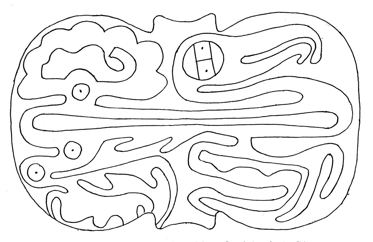
The standard image is a raptor, usually interpreted as a vulture with a hooked beak, splayed talons, and a scalloped tail (Caldwell 2015, 105). But rotate the Wilmington or Meigs tablet sideways and the paired bird heads resolve into small smiling human faces, with the beaks curling off their chins like beards; Penney counted the hidden "smiling face" motif six times across the thirteen classic designs (Penney 1980, 14-15). Turn the Gaitskill Clay or Lakin A tablet upside down and a monstrous frontal mask assembles itself out of what had been wings and feet (Caldwell 2015, 116-119). Romain showed that on the Lakin A tablet the detached little head looks human one way up and avian the other, so that "by physical manipulation of the piece, the viewer can control the human-to-bird transformation" (Romain 2009, 133-135).
Wait. So, the tablet is not a picture of a bird? It is a picture of becoming a bird, operated by hand?
Ah shit, that’s right. We’re back to werewolves again. I’ve talked plenty about the cosmology of the Adena and Hopewell, from shitting themselves in caves to smoking hallucinogenic tobacco. Have fun, I’ll be here when you get back from those reads.
But Caldwell went furthest, on a tablet found near Waverly in 1899. He had published about the McKensie Tablet himself in 1997 and then spent a decade discovering everything he had missed, such as a hawk hidden in the creature's bowels, a second bird folded into its tail, and, in one corner, a small turkey vulture head enveloped inside a larger vulture head with a different nostril, which is a species marker. It is the wide nostril of the timid turkey vulture hidden inside the slit nostril of the black vulture (Caldwell 2015, 108-114). Caldwell also suspects another species pairing on the Meigs tablet: the left bird’s thin hooked beak and globular head looks like a passenger pigeon facing a vulture with a rayed dead eye, which would put the continent’s great abundance bird and its great death-eater on one plate, beak to beak (Caldwell 2015, 111-112).
Some of these figures are nearly invisible on the stone and only emerge in the negative, in a rubbing, in the print (Caldwell 2015, 110). His conclusion is the imagery "was designed to be seen in stages," arranged "to trick observers into believing they have seen the whole picture," an encryption meant to mirror "a layered cosmology or initiatory process that involved phased recognitions" (Caldwell 2015, 108). The tablets are "some of the most tightly packed and encrypted embodiments of an ideology ever made" (Caldwell 2015, 125). If you want some examples, it’s best to see it represented in drawing where the lines stand out and you can see the birds and faces better. Or just browse Caldwell’s paper that have copious close-ups of different reliefs (negative and otherwise).
Wow! You saw the bird. Congratulations. Later, when you were ready, somebody turned the stone in your hands and you saw the man inside the bird, and you could never again see the tablet the way the uninitiated saw it. The reading order was part of their canon.
Now look closely at the creatures on the tablets, at their wing joints, their palms, their hips, and, on the Berlin Tablet, the anus, because yes, the Adena engraver marked that too. At these spots the designs carry a small motif: a dot inside a circle. The nucleated circle sits at the principal joints and body openings of the bird-human figures, and on the palms of their hands (Hall 1979, 261; Carr and Smyth 2019, 174).
Robert Hall, the great comparativist of Eastern Woodlands religion, recognized the motif, because the same convention wraps around most of the continent. Northwest Coast artists put faces and barred ovals at the same anatomical stations; Boas recorded that the Kwakiutl understood the design as "a cross section of the ball and socket joint," and at Seymour Inlet the Kwakiutl word for the soul is, literally, "human mask" (Hall 1979, 261). For the Tlingit, a face repeated on an animal's body parts "signified the indwelling anthropomorphic soul" (Hall 1979, 261). Across the Bering Strait, the Chukchee held that hands and feet have their own limb souls, which can be lost one at a time, and Bogoras recorded the diagnosis in one immortal line: "the Chukchee call a man whose nose is easily frost-bitten 'short of souls'" (Hall 1979, 261). Catlin painted Mandan Okipa dancers in 1832 wearing concentric-circle marks at the ankles, knees, hips, wrists, elbows, and shoulders, the same stations the Adena engraver had dotted two thousand years earlier (Hall 1997, 126-127).
This is the doctrine anthropologists of religion call soul dualism, or the more appropriate version in this case, soul plurality: a person is not one ghost in one machine. A person is a multitude of souls. There is a free soul, which travels in dreams and trance and leaves for good at death, and there are body souls, seated in the joints and organs and bones, the ones you feel as pulse and motion (Carr and Smyth 2019, 165, 174-175). The marked spots are where the arteries surface, or where the pulse throbs, or where the body opens. These are the places you can actually feel that something alive is in there, knocking (Hall 1979, 261-262).
Christopher Carr and Heather Smyth, tallying the Adena convention across the engraved tablets, count thirteen soul locations depicted in Adena ceremonial art, against fifteen depicted by historic Northwest Coast artists and thirty-eight used by Minnesota Mide'wiwin healers within living memory (Carr and Smyth 2019, 183). Nine of the fourteen engraved tablets known to them carry the marks (Carr and Smyth 2019, 184).
So the tablet was an owner's manual, applied directly to the device. You.
And we can watch the doctrine continue to evolve, because the Hopewell down the Scioto wrote the next edition in copper! Carr and Smyth looked at 189 Scioto Hopewell inhumations buried with "power artifacts," the mirrors, breastplates, mica, galena, and small pipes that historic Woodland peoples used to move souls. The artifacts cluster at seventeen kinds of body positions, or twenty-eight positions once you count pairs. That’s at least twenty-eight souls' worth of parking spaces, with the head marked most of all, the seat of the free soul (Carr and Smyth 2019, 182-183). Copper breastplates lie under heads, chests, hips, and knees like mirrors set at the doors souls use, to portal them out, or guide them, or politely deflect them (Carr and Smyth 2019, 174, 184). One burial under Hopewell Mound 25 has a mica translucent human effigy placed emerging from the top of the skeleton's skull, the free soul, mid-departure, caught in the act by the funeral director (Carr and Smyth 2019, 183).
And we know that the two systems are measurably different dialects of one theology because the Hopewell placements correlate first with major arteries and pulse points (Jaccard coefficients of .88 and .71, because yes, we are doing set-theoretic statistics on the afterlife now. We’re goddamn professionals here), while the Adena tablet convention leaned on joints and places of body movement instead (Carr and Smyth 2019, 184).
Why does a society pour this much engineering into soul logistics? In the Huron theology that gives us our clearest window, the free soul leaves for the land of the dead, but body souls stay with the bones; the Huron word for those souls, atisken, is also the word for bones (Carr and Smyth 2019, 165-166). At the Feast of the Dead, allied villages took up their dead together and stirred the bones of hundreds of people into one ossuary, mingling the bone-souls into a single congregation. The logic, as Carr and Smyth reconstruct it, was "We are allies, always, because the souls of our ancestors and relations are allies, always" (Carr and Smyth 2019, 165-166).
But the Scioto Hopewell burned it instead of stirring it. At the closing of great ceremonies, the paraphernalia and dress of whole allied communities went into one fire until the copper ran together and the obsidian foamed into pumice. The souls melted together (Carr and Smyth 2019, 169).
So, in sum, the Adena had writing. It was just never going to be caught dead on paper.
And before someone screams "AI slop" in the comments: nope, just a human with a dose of the 'tism and a passion for the most memeable of states.